Hiking the Mont Blanc Massif, Day 10 - Courmayeur 勃朗峰山脉徒步游第十天
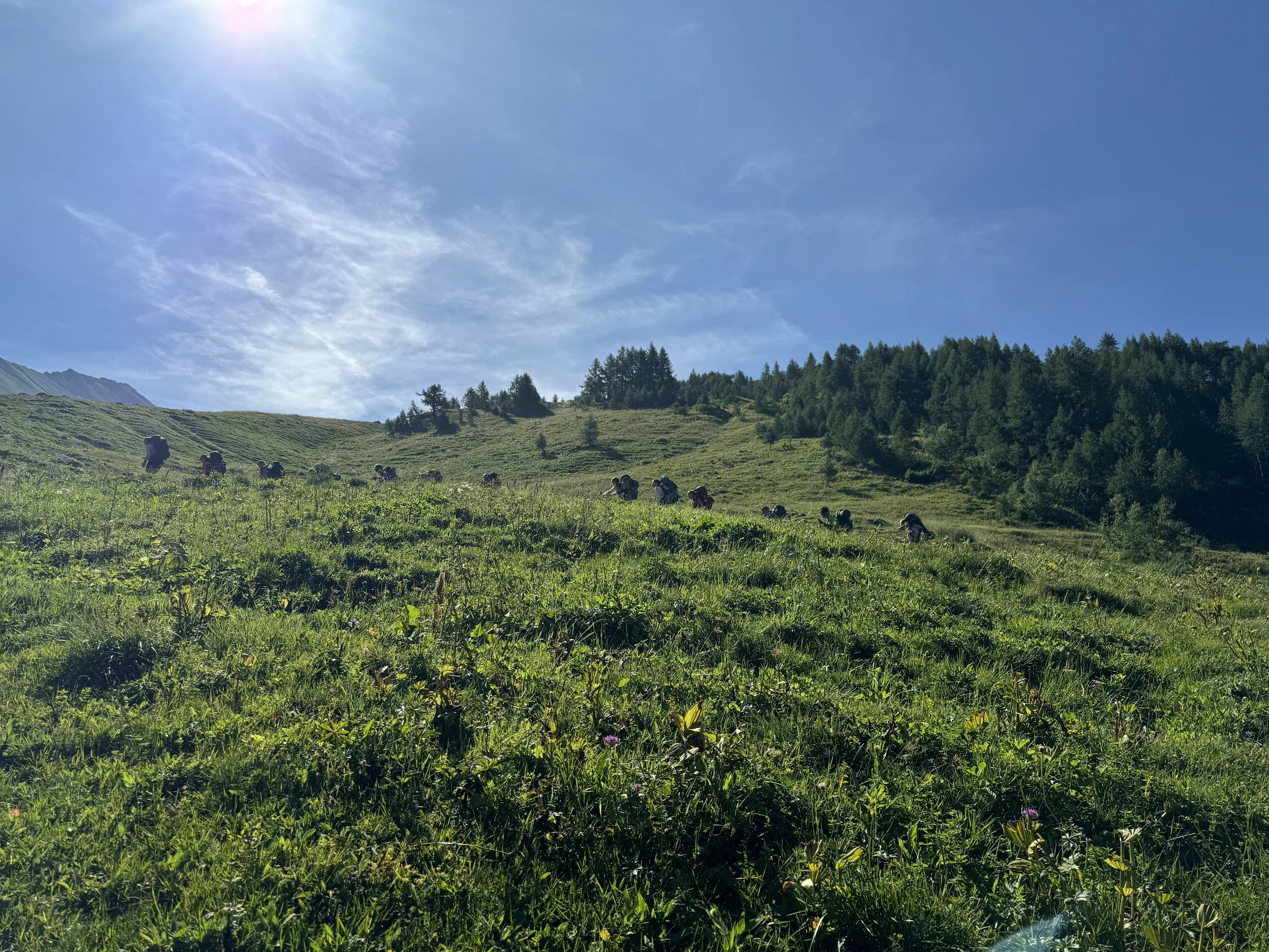
August 5, 2024: Today marks the final day of our Mont Blanc adventure. We hiked the famed Val Veny Balcony Trail, a stunning section of the Tour du Mont Blanc (TMB) near Courmayeur. The trail is aptly named the "Balcony" because it offers unparalleled, panoramic views of Mont Blanc. The route is relatively long, winding along the mountainside, with steep ascents and descents at both ends. After yesterday’s 7-mile (11 km) hike, we were all feeling a bit fatigued, but we didn’t want to miss out on this last opportunity, so we decided to give it one more effort. At breakfast, we once again encountered the Australian couple, who were heading out for another day of UTMB race training. They gave us more words of encouragement, which lifted our spirits.
We took the free shuttle bus to the base of the mountain and began our ascent. It was clear that our legs were sore today, and climbing felt more challenging than usual. However, we were pleasantly surprised to find that we completed the first uphill section faster than expected. To save time, we decided not to stop at the first mountain hut (Refuge Bonatti) and pressed on. Shortly after, we crossed paths with the Australian couple again, who were running the same TMB route but in the opposite direction. They had already run 14 kilometers since leaving the hotel that morning and cheerfully told us that the trail ahead was beautiful. It seemed like fate that we kept encountering them just when we needed encouragement.


The next section of the trail was relatively flat, with fewer ups and downs, allowing us to walk directly towards Mont Blanc, getting closer with every step. We had planned to take a break and have lunch at the second mountain hut (Refuge Bertone), but it turned out to be much farther away than we had anticipated. After several hours of hiking, we finally spotted the roof, and our spirits soared. We enjoyed a well-deserved lunch and took a break at the hut before starting our final descent back to town.
The descent was challenging, starting with a steep, rocky path. We even saw a hiker take a tumble right in front of us. Over the past few days, with steep and long trails, we’ve come to realize that descending can be more strenuous than ascending. However, knowing this was the final leg of our journey, we felt a sense of relief and lightness as we made our way down.
Earlier in the day, we had met a group of 9- and 10-year-old children on the bus, accompanied by their teacher on a mountain hiking trip. They got off at the same stop as us. We saw them again at the mountain hut during lunch and once more during our descent. We chatted with their teacher, who told us that the children were part of a ski club and very familiar with the mountains. They hiked 6 or 7 kilometers more than we did and soon left us far behind, disappearing from view. Today, we covered 8.3 miles (13.2 km), with an elevation gain of 1,720 feet, taking us five and a half hours.
We finally arrived back in Courmayeur, signaling the end of our Mont Blanc hiking adventure.
Over the past ten days, we hiked 43 miles (69 kilometers) on the TMB, with a total elevation gain of 8,900 feet. Since we used buses and cable cars along the way, our total descent—often harder on the knees—was greater than the ascent. The sections of the TMB we hiked were challenging but manageable, and without a doubt, this has been one of the most rewarding hiking experiences we’ve ever had. The mountain huts (refuges) along the way were incredibly convenient, typically no more than 5 kilometers apart, offering drinks and good food. The "comfort version" of the TMB we chose suited us perfectly. Whether you consider yourself fit or not, everyone should come here and experience it at least once—stay for three or four days, buy a cable car pass, and explore. We might just come back again.
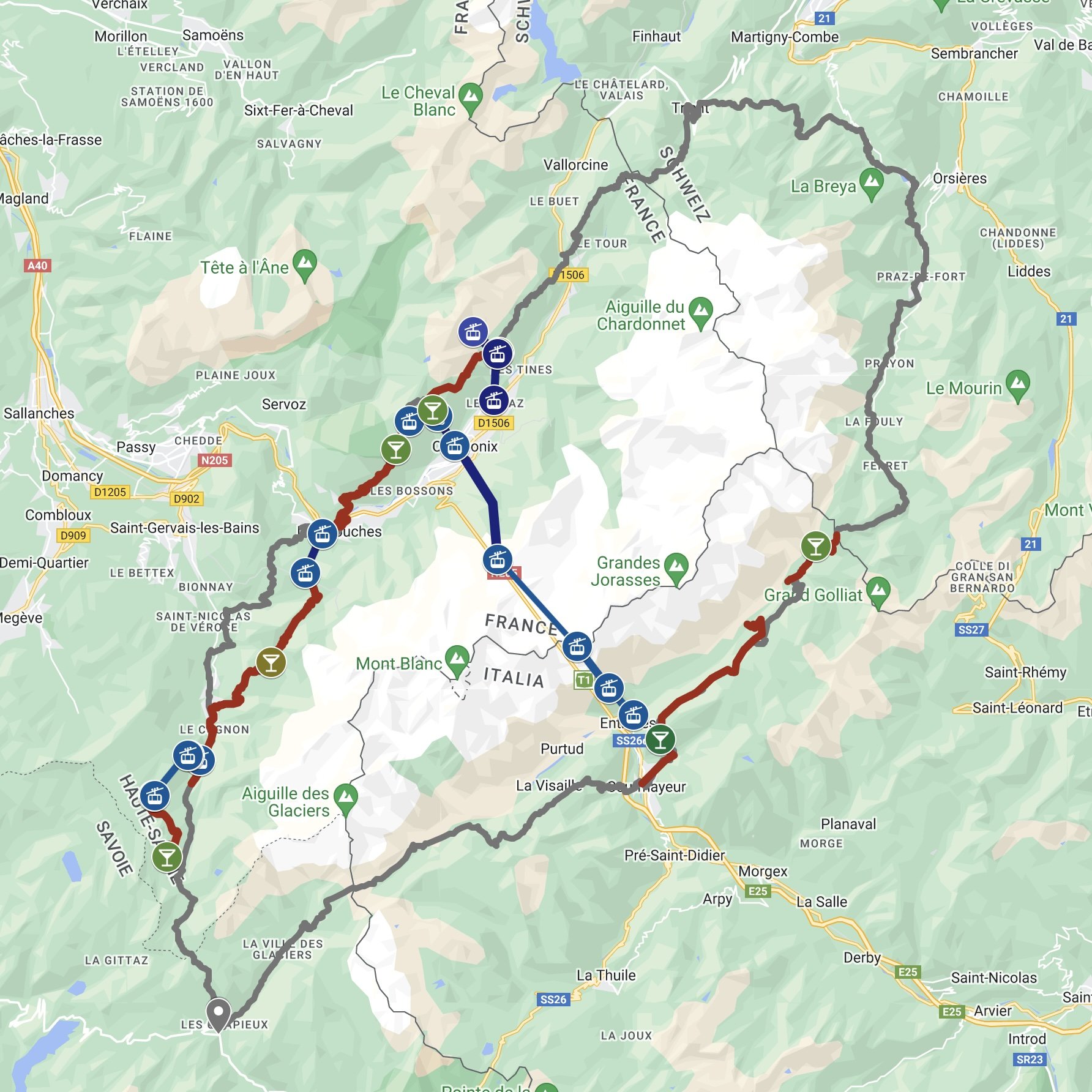
The map shows the hiking routes and cable car lines we took. The gray line represents the traditional TMB.
勃朗峰山脉徒步游第十天-库马约尔
2024年8月5日: 今天是我们这次勃朗峰行的最后一天。我们走在著名的瓦尔山谷大阳台山道,是Courmayeur的一段TMB,沿途可以一直看着勃朗峰走,非常漂亮,所以称之为大阳台。路有点长,大部分在山上,二端上下坡比较陡。昨天刚走了7英里/11公里,大家都有点累,但又不想错过这机会,决定再努力一下。早餐时又碰到那对澳大利亚夫妇,正准备出门开始一天的UTMB跑步训练。又是对我们一番鼓励。
我们还是坐免费的大巴来到山脚下,开始往山上走。很明显今天腿有点酸,爬坡觉得很累。没想到的是当我们走完第一段上坡路来到山上时,发现我们花了比预期还少的时间。为了省点时间,我们没在第一个小山屋(Refuge Bonatti)停留,而是接着走。没多久迎面又跑来那对澳大利亚夫妇,他们今天跑我们这条TMB线路,只是相反的方向。从早上离开旅馆到现在他们已经跑了十四公里了,还高兴地对我们说前面很漂亮。感觉与这对老外很有缘,每次在我们有顾虑时他们会出现,鼓励我们。
接下来很长一段路相对来说比较平坦,没有太多的大起大落,真的就是一路迎着勃朗峰走且越走越近。计划在第二个小山屋(Refuge Bertone)休息吃午饭,但这小山屋比我们想象的要远很多。走了好几个小时才终于看到屋顶,心里别提有多高兴了。 在小山屋好好吃了顿午饭同时也得到了必要的休息之后,我们开始今天的最后一段徒步下山回镇。
下山的路不容易,一上来就在乱石中不停地往下走,眼看着一老外就在眼前摔一跤。这些天爬山,坡度大且路还长,充分体会到下山比上山更痛苦。 想到这是这次行程的最后一段路程,最后的冲刺,心情反而变得轻松起来。
早晨在大巴上碰见一群9,10岁男女小学生,老师带着出来爬山,他们在终点下车。中午在小山屋吃饭时又遇到他们。在我们下山时再次遇见他们,与带队老师聊了几句,告诉说孩子们是滑雪俱乐部的,对山熟悉。他们比我们多走了六,七公里,一会儿就远远超过了我们,跑得无影无踪。我们今天走了8.3英里/13.2公里,攀高1720英尺,走了五个半小时。终于下到Courmayeur镇,我们的勃朗峰徒步游也到此结束。
在过去的十天里,我们在TMB(环勃朗峰)徒步了43英里(69公里),总共攀升了8,900英尺。由于我们在途中使用了巴士和缆车,导致总的下降高度——这对膝盖的损伤更大——比攀升高度还要多。我们所走过的TMB部分虽然具有挑战性,但并不困难,毫无疑问,这是我们做过的最棒的徒步旅行之一。沿途的小屋(refuges)非常方便,通常距离徒步路线不会超过5公里,可以在那里享用饮品和不错的食物。我们选择的TMB“舒适版”非常适合我们。无论你是否认为自己体能合适,每个人至少应该来这里体验一下,住上三,四天,买张缆车通票,上上下下看看走走。我们或许还会再来。
地图显示了徒步路线以及缆车线路。灰色线传统的TMB。


